• Attractions
      • Back
      • Amusement Parks
      • Archaeology
      • Architecture
      • Art Galleries
      • Culture & Festivals
      • Forests & Jungles
      • Fortresses & Palaces
      • Hill-Tracts
      • Industries
      • Islands
      • Lakes
      • Land Ports
      • Libraries
      • Mountains
      • Movie Theaters
      • Museums
      • Parks & Zoos
      • Rivers
      • Sea Beaches
      • Stadiums
      • Tea States
      • Universities
      • Waterfalls
      • UNESCO World Heritage
  • Emergency & Services
      • Back
      • Airlines
      • Ambulance
      • Blood Banks
      • Fire Services
      • Foreign Missions
      • Hospitals
      • Police Stations
      • Security Services
      • Things To Avoid
      • Useful Words and Phrases
  • Blog
  • Agricultural Landuse
  • Agriculture Map
  • Agroecological Zones
  • Air Transport
  • Ancient Monuments
  • Archaeological Sites
  • Arsenic Contamination
  • Average Temperature
  • Bay of Bengal
  • Bio-Ecological Zones
  • Buddhist Vihara
  • Climate Map
  • Contour Map
  • Cropping Pattern
  • Cyclone Maps
  • Disaster Prone Areas
  • Earthquake Maps
  • Embankment Map
  • Flood Maps
  • Forests of Bangladesh
  • Forts in Bangladesh
  • Gas Blocks
  • Gas Fields & Gas Pipeline
  • General Soil Map
  • Geological Group Formation
  • Ground Water Zones
  • Historical Mosques
  • Land Ports
  • Landsat TM Image
  • Locations of Faults
  • Major Industries
  • Mineral Resources
  • Navigation Charts
  • Primary Power Grid System
  • Problem Soil Map
  • Railway Route Map
  • Rainfall Map
  • River Transport
  • Riverbank Erosion Map
  • Rivers of Bangladesh
  • Road Network
  • Rural House Pattern (1981)
  • Sectors of Liberation War
  • Soil Tracts
  • Tectonic Map
  • Wildlife Distribution

Flood Maps: Bangladesh

  • Map-1
  • Map-2
  • Map-3
  • Map-4
  • Map-5
  • Map-6
  • Info

Map-1

Flood Prone Area Map Bangladesh

Map Courtesy: Institute of Geographie, University of Berne

Map-2

Flood Prone Area of Bangladesh

Map Courtesy: Bangladesh Agricultural Research Council

Map-3

Flood Affected Areas (1955) of Bangladesh

Map Courtesy: Banglapedia

Map-4

Flood Affected Areas (1974) of Bangladesh

Map Courtesy: Banglapedia

Map-5

Flood Affected Areas (1988) of Bangladesh

Map Courtesy: Banglapedia

Map-6

Flood Affected Areas (1998) of Bangladesh

Map Courtesy: Banglapedia

Info

The South Asian country of Bangladesh located next to India is prone to flooding due to being situated on the Ganges Delta and the many tributaries flowing into the Bay of Bengal. The coastal flooding twinned with the bursting of Bangladesh's river banks is common and severely affects the landscape and society of Bangladesh. 75% of Bangladesh is less than 10m above sea level and 80% is flood plain, therefore rendering Bangladesh a nation very much at risk of further widespread damage despite its development. Whilst more permanent defences, strengthened with reinforced concrete, are being built, many embankments are composed purely of soil and turf and made by local farmers. Flooding normally occurs during the monsoon season from June to September. The convectional rainfall of the monsoon is added to by relief rainfall caused by the Himalayas. Meltwater from the Himalayas is also a significant input and flood every year. This often lasts for about 1 month.

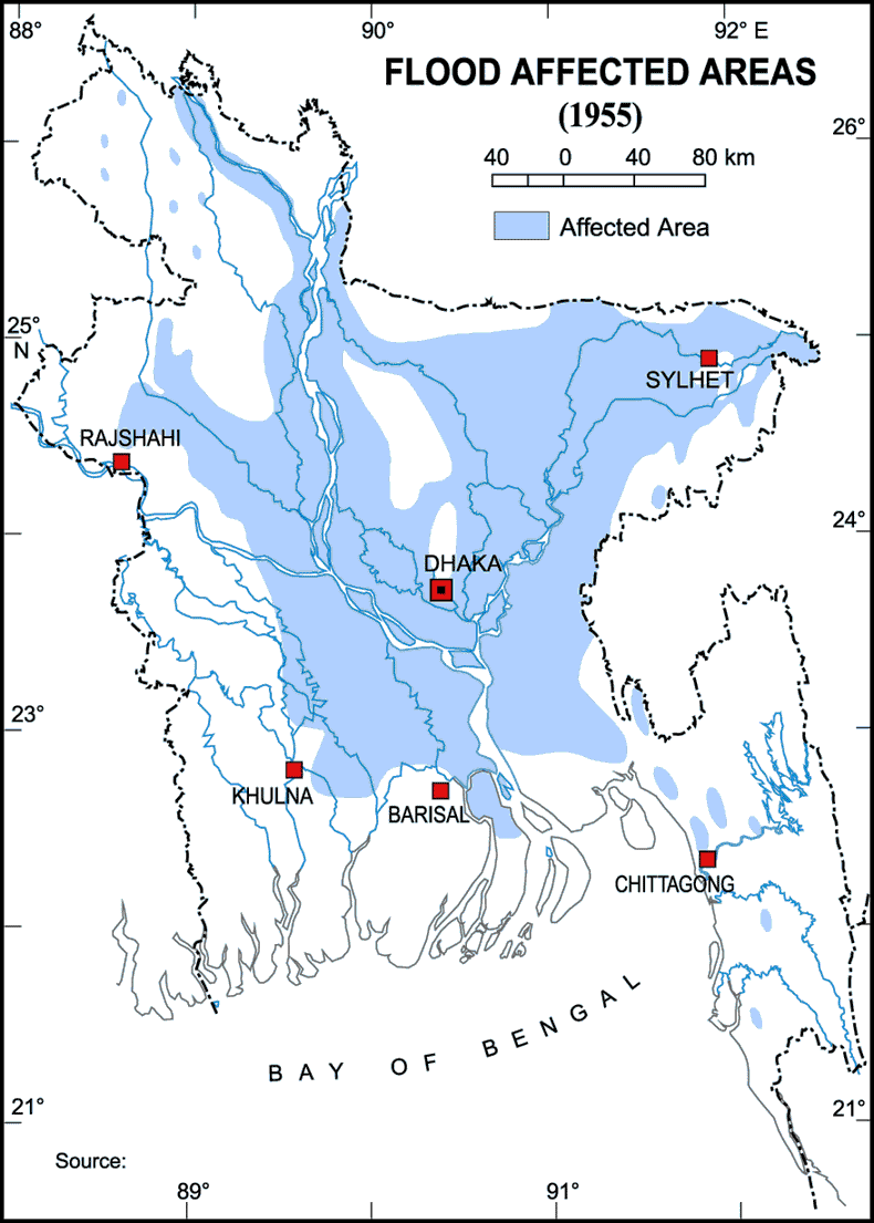
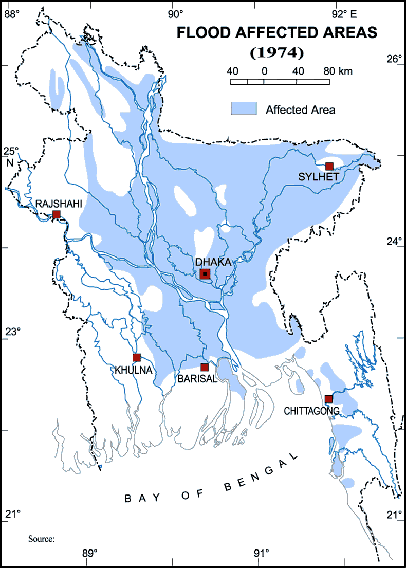
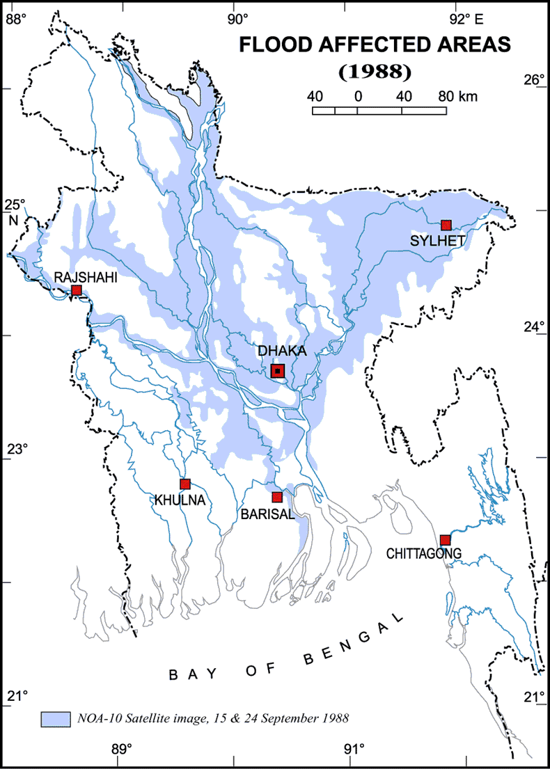
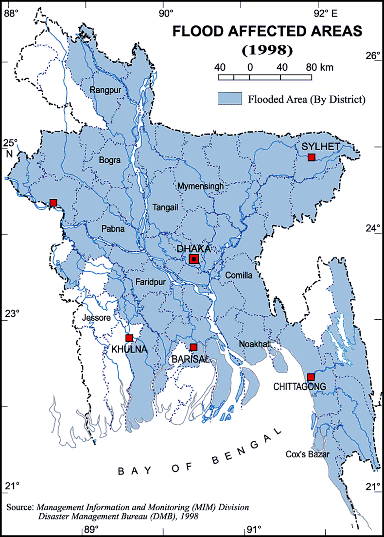
Each year in Bangladesh about 26,000 km2, (around 18%) of the country is flooded, killing over 5,000 people and destroying more than 7 million homes. During severe floods the affected area may exceed 75% of the country, as was seen in 1998. This volume is 95% of the total annual inflow. By comparison, only about 187,000 million m3, of streamflow is generated by rainfall inside the country during the same period. The floods have caused devastation in Bangladesh throughout history, especially during the years 1966, 1987, 1988 and 1998. The 2007 South Asian floods also affected a large portion of Bangladesh.

Small scale flooding in Bangladesh is required to sustain the agricultural industry, as sediment deposited by floodwater fertilizes fields. The water is required to grow rice, so natural flooding replaces the requirement of artificial irrigation, which is time consuming and costly to build. Salt deposited on fields from high rates of evaporation is removed during floods, preventing the land from becoming infertile. The benefits of flooding are clear in El Niño years when the monsoon is interrupted. As El Niño becomes increasingly frequent, and flood events appear to become more extreme, the previously reliable monsoon may be succeeded by years of drought or devastating floods. Also, some three thousand people were left homeless or killed.

Source: Wikipedia.

Details
Last Updated: 06 September 2017
© The Bangladesh Network 2014 - 2025
Tourism Directory of BANGLADESH.
  • About
  • Contact
  • License
  • Privacy Policy
  • Terms of Use
Back to top