• Attractions
      • Back
      • Amusement Parks
      • Archaeology
      • Architecture
      • Art Galleries
      • Culture & Festivals
      • Forests & Jungles
      • Fortresses & Palaces
      • Hill-Tracts
      • Industries
      • Islands
      • Lakes
      • Land Ports
      • Libraries
      • Mountains
      • Movie Theaters
      • Museums
      • Parks & Zoos
      • Rivers
      • Sea Beaches
      • Stadiums
      • Tea States
      • Universities
      • Waterfalls
      • UNESCO World Heritage
  • Emergency & Services
      • Back
      • Airlines
      • Ambulance
      • Blood Banks
      • Fire Services
      • Foreign Missions
      • Hospitals
      • Police Stations
      • Security Services
      • Things To Avoid
      • Useful Words and Phrases
  • Blog
  • Agricultural Landuse
  • Agriculture Map
  • Agroecological Zones
  • Air Transport
  • Ancient Monuments
  • Archaeological Sites
  • Arsenic Contamination
  • Average Temperature
  • Bay of Bengal
  • Bio-Ecological Zones
  • Buddhist Vihara
  • Climate Map
  • Contour Map
  • Cropping Pattern
  • Cyclone Maps
  • Disaster Prone Areas
  • Earthquake Maps
  • Embankment Map
  • Flood Maps
  • Forests of Bangladesh
  • Forts in Bangladesh
  • Gas Blocks
  • Gas Fields & Gas Pipeline
  • General Soil Map
  • Geological Group Formation
  • Ground Water Zones
  • Historical Mosques
  • Land Ports
  • Landsat TM Image
  • Locations of Faults
  • Major Industries
  • Mineral Resources
  • Navigation Charts
  • Primary Power Grid System
  • Problem Soil Map
  • Railway Route Map
  • Rainfall Map
  • River Transport
  • Riverbank Erosion Map
  • Rivers of Bangladesh
  • Road Network
  • Rural House Pattern (1981)
  • Sectors of Liberation War
  • Soil Tracts
  • Tectonic Map
  • Wildlife Distribution

Arsenic Contamination: Bangladesh

  • Map-1
  • Map-2
  • Map-3
  • Info

Map-1

Arsenic Contamination Map Bangladesh

Map Courtesy: Banglapedia

Map-2

Geologic Units and Arsenic Concentrations in Groundwater in Bangladesh

Geologic units and arsenic concentrations in groundwater in Bangladesh

Map Courtesy: International Journal of Environmental Research and Public Health

Map-3

Distribution of Arsenic in the Context of the Generalized Tectonic Map of Bangladesh

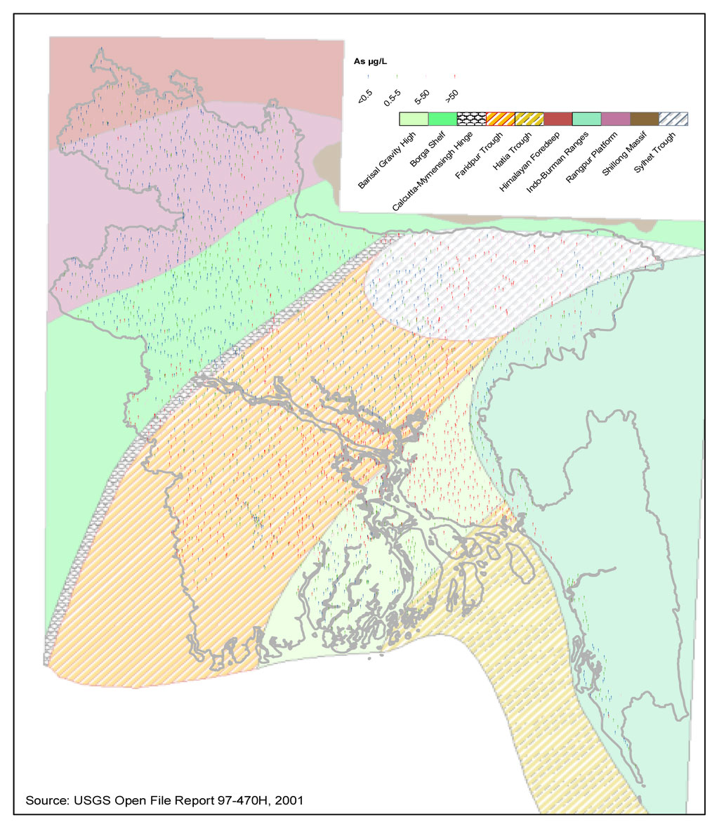
Distribution of arsenic in the context of the generalized tectonic map of Bangladesh

Map Courtesy: International Journal of Environmental Research and Public Health

Info

Arsenic contamination of the groundwater in Bangladesh is a serious problem. Prior to the 1970s, Bangladesh had one of the highest infant mortality rates in the world. Ineffective water purification and sewage systems as well as periodic monsoons and flooding exacerbated these problems. As a solution, UNICEF and the World Bank advocated the use of wells to tap into deeper groundwater. Millions of wells were constructed as a result. Because of this action, infant mortality and diarrheal illness were reduced by fifty percent. However, with over 8 million wells constructed, approximately one in five of these wells is now contaminated with arsenic above the government's drinking water standard.

In the Ganges Delta, the affected wells are typically more than 20 meters and less than 100 meters deep.[citation needed] Groundwater closer to the surface typically has spent a shorter time in the ground, therefore likely absorbing a lower concentration of arsenic; water deeper than 100 m is exposed to much older sediments which have already been depleted of arsenic.[5]

The issue came to international attention in 1995.[6][7][8] The study conducted in Bangladesh involved the analysis of thousands of water samples as well as hair, nail, and urine samples. They found 900 villages with arsenic above the government limit.

Criticism has been leveled at the aid agencies, who denied the problem during the 1990s while millions of tube wells were sunk. The aid agencies later hired foreign experts who recommended treatment plants that were inappropriate to the conditions, were regularly breaking down, or were not removing the arsenic.

Throughout Bangladesh, as tube wells get tested for concentrations of arsenic, ones which are found to have arsenic concentrations over the amount considered safe are painted red to warn residents that the water is not safe to drink.

Source: Wikipedia

Details
Last Updated: 06 September 2017
© The Bangladesh Network 2014 - 2025
Tourism Directory of BANGLADESH.
  • About
  • Contact
  • License
  • Privacy Policy
  • Terms of Use
Back to top