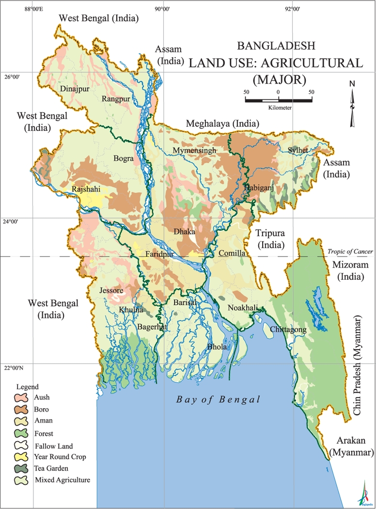
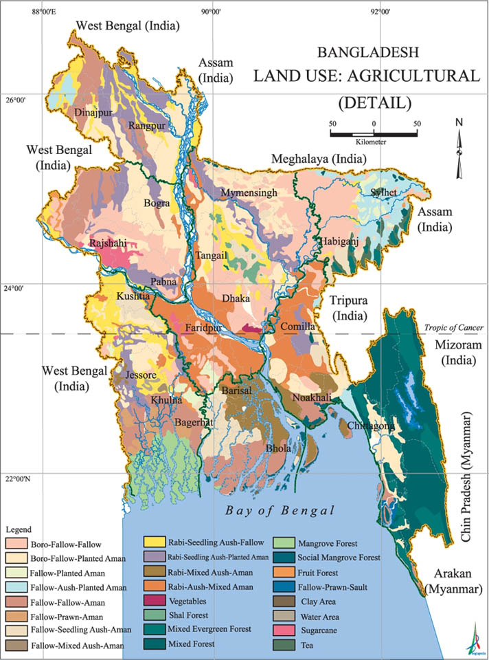
• Attractions
      • Back
      • Amusement Parks
      • Archaeology
      • Architecture
      • Art Galleries
      • Culture & Festivals
      • Forests & Jungles
      • Fortresses & Palaces
      • Hill-Tracts
      • Industries
      • Islands
      • Lakes
      • Land Ports
      • Libraries
      • Mountains
      • Movie Theaters
      • Museums
      • Parks & Zoos
      • Rivers
      • Sea Beaches
      • Stadiums
      • Tea States
      • Universities
      • Waterfalls
      • UNESCO World Heritage
  • Emergency & Services
      • Back
      • Airlines
      • Ambulance
      • Blood Banks
      • Fire Services
      • Foreign Missions
      • Hospitals
      • Police Stations
      • Security Services
      • Things To Avoid
      • Useful Words and Phrases
  • Blog
  • Agricultural Landuse
  • Agriculture Map
  • Agroecological Zones
  • Air Transport
  • Ancient Monuments
  • Archaeological Sites
  • Arsenic Contamination
  • Average Temperature
  • Bay of Bengal
  • Bio-Ecological Zones
  • Buddhist Vihara
  • Climate Map
  • Contour Map
  • Cropping Pattern
  • Cyclone Maps
  • Disaster Prone Areas
  • Earthquake Maps
  • Embankment Map
  • Flood Maps
  • Forests of Bangladesh
  • Forts in Bangladesh
  • Gas Blocks
  • Gas Fields & Gas Pipeline
  • General Soil Map
  • Geological Group Formation
  • Ground Water Zones
  • Historical Mosques
  • Land Ports
  • Landsat TM Image
  • Locations of Faults
  • Major Industries
  • Mineral Resources
  • Navigation Charts
  • Primary Power Grid System
  • Problem Soil Map
  • Railway Route Map
  • Rainfall Map
  • River Transport
  • Riverbank Erosion Map
  • Rivers of Bangladesh
  • Road Network
  • Rural House Pattern (1981)
  • Sectors of Liberation War
  • Soil Tracts
  • Tectonic Map
  • Wildlife Distribution

Agricultural Landuse: Bangladesh

  • Map-1
  • Map-2
  • Map-3
  • Info

Map-1

Agricultural Landuse Map Bangladesh (1997)

Map Courtesy: Banglapedia

Map-2

Major Agricultural Landuse Map Bangladesh

Map Courtesy: Banglapedia

Map-3

Detail Agricultural Landuse Map Bangladesh

Map Courtesy: Banglapedia

Info

LanduseĀ  human activities that are directly related to land, making use of its resources or having an impact upon it. Land cover is the physical attributes of the land, while landuse is a pattern of human activities undertaken within a socio-economic context. Natural land cover is changed by use of man in meeting cultivation, homestead or other demands.

Physiographically Bangladesh may be divided into three major units: hills of the north, northeast and southeast covering about 12 percent of the total area; Pleistocene terraces stretching over only 8 percent area and floodplains accounting for 80 percent of the total area. Of the three determinants, land levels in relation to flood depth are of major importance for landuse. Even occupation types in the rural areas are dependent on flooding characteristics - depth, duration and timing. There are regional variations in the distribution of different land types and landuse pattern.

Landuse pattern in Bangladesh is determined by physiography, climate and land levels in relation to flooding. In this context land includes all land and water within the national boundaries of the country. Water bodies within land areas are therefore considered to be a part of land. The use of land is of paramount importance in a country which is thickly populated and still very reliant on primary production.

Land and water are the two major natural resources of Bangladesh. The total area of Bangladesh is 147,570 sq km of which 9,734 sq km is under inland waterbodies (river, beels, etc), homesteads cover 11,227 sq km, urban fabric covers 950 sq km and forests 2,154 sq km. This account includes the shallow estuarine water surface between the offshore islands in the delta.

Details
Last Updated: 06 September 2017
© The Bangladesh Network 2014 - 2025
Tourism Directory of BANGLADESH.
  • About
  • Contact
  • License
  • Privacy Policy
  • Terms of Use
Back to top