• Attractions
      • Back
      • Amusement Parks
      • Archaeology
      • Architecture
      • Art Galleries
      • Culture & Festivals
      • Forests & Jungles
      • Fortresses & Palaces
      • Hill-Tracts
      • Industries
      • Islands
      • Lakes
      • Land Ports
      • Libraries
      • Mountains
      • Movie Theaters
      • Museums
      • Parks & Zoos
      • Rivers
      • Sea Beaches
      • Stadiums
      • Tea States
      • Universities
      • Waterfalls
      • UNESCO World Heritage
  • Emergency & Services
      • Back
      • Airlines
      • Ambulance
      • Blood Banks
      • Fire Services
      • Foreign Missions
      • Hospitals
      • Police Stations
      • Security Services
      • Things To Avoid
      • Useful Words and Phrases
  • Blog
  • Agricultural Landuse
  • Agriculture Map
  • Agroecological Zones
  • Air Transport
  • Ancient Monuments
  • Archaeological Sites
  • Arsenic Contamination
  • Average Temperature
  • Bay of Bengal
  • Bio-Ecological Zones
  • Buddhist Vihara
  • Climate Map
  • Contour Map
  • Cropping Pattern
  • Cyclone Maps
  • Disaster Prone Areas
  • Earthquake Maps
  • Embankment Map
  • Flood Maps
  • Forests of Bangladesh
  • Forts in Bangladesh
  • Gas Blocks
  • Gas Fields & Gas Pipeline
  • General Soil Map
  • Geological Group Formation
  • Ground Water Zones
  • Historical Mosques
  • Land Ports
  • Landsat TM Image
  • Locations of Faults
  • Major Industries
  • Mineral Resources
  • Navigation Charts
  • Primary Power Grid System
  • Problem Soil Map
  • Railway Route Map
  • Rainfall Map
  • River Transport
  • Riverbank Erosion Map
  • Rivers of Bangladesh
  • Road Network
  • Rural House Pattern (1981)
  • Sectors of Liberation War
  • Soil Tracts
  • Tectonic Map
  • Wildlife Distribution

Contour: Bangladesh

  • Map-1
  • Map-2
  • Map-3
  • Map-4
  • Info

Map-1

Simplified Contour Map Bangladesh

Map Source: The Bangladesh Network.

Map-2

Elevation Map Bangladesh

Map Source: CartoGIS, College of Asia and the Pacific, The Australian National University.

Map-3

Contour Map of Bangladesh

Map Courtesy: HARVARD UNIVERSITY.

Map-4

Contour Map of Bangladesh

Map Source: Scientific Figure on ResearchGate.

Info

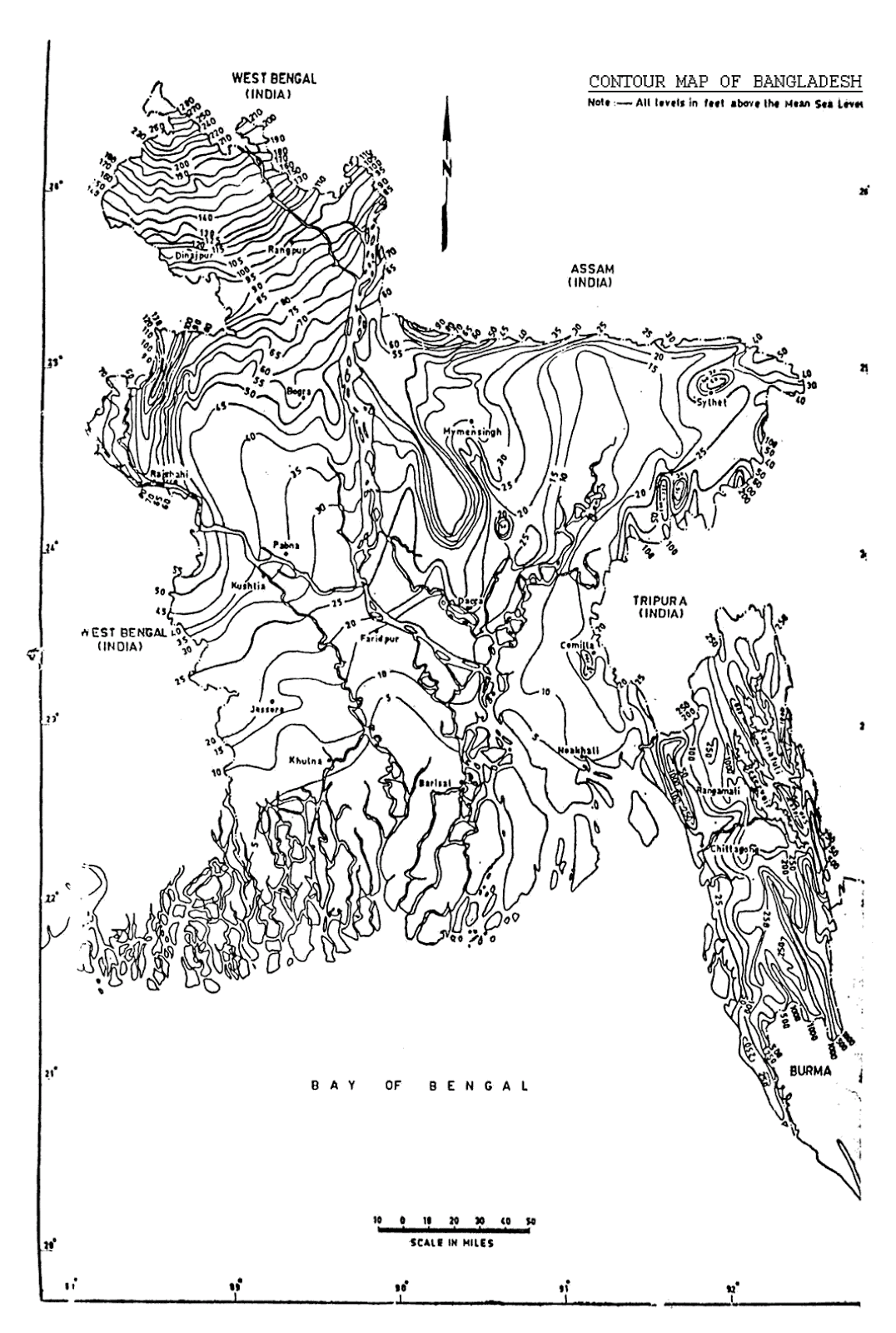
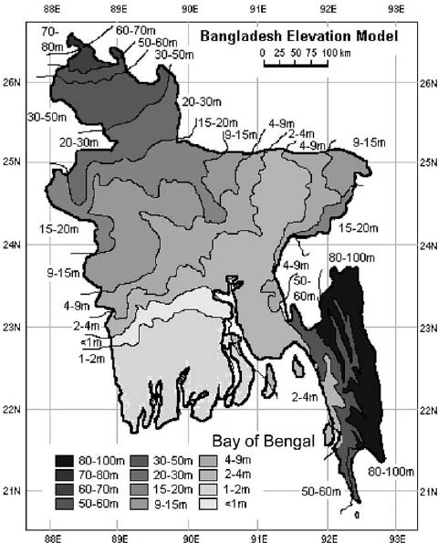
A contour map or topographic map also elevation map is a type of map characterized by large-scale detail and quantitative representation of relief, using contour lines but, historically, using a variety of methods. Traditional definitions require a topographic map to show both natural and man-made features. A topographic map is typically published as a map series, made up of two or more map sheets that combine to form the whole map. A contour line is a combination of two line segments that connect but do not intersect; these represent elevation on a topographic map.

The Canadian Centre for Topographic Information provides this definition:
A topographic map is a detailed and accurate graphic representation of cultural and natural features on the ground.

Source: Wikipedia

Details
Last Updated: 06 September 2017
© The Bangladesh Network 2014 - 2025
Tourism Directory of BANGLADESH.
  • About
  • Contact
  • License
  • Privacy Policy
  • Terms of Use
Back to top