Sirajganj District
Maps
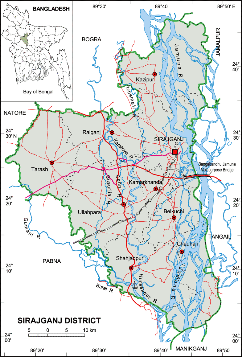
Map of Sirajganj District. Map Courtesy: Banglapedia
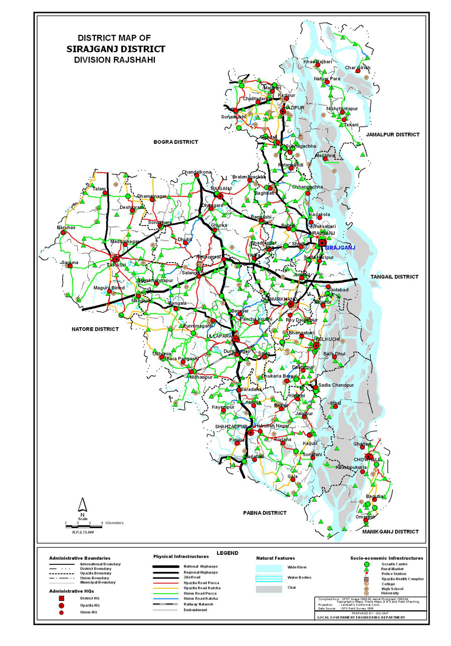
Map of Sirajganj District. Map Courtesy: LGED Bangladesh
Basic Info
Basic Information |
| Sirajganj District (Rajshahi division) with an area of 2,497.92 sq km, is bounded by bogra district on the north, pabna district on the south, tangail and jamalpur districts on the east, Pabna, natore and Bogra districts on the west. Main rivers are Jamuna, Baral, Ichamati, Karatoa and Phuljuri. About 10% area of the chalan beel is located in the tarash upazila of this district. Annual average temperature: maximum 34.6 oC, minimum 11.9 oC; annual rainfall 1610 mm. |
At a Glance |
|
| Area: | 2,497.92 Km2 |
| Upazila Road: | 619.63 Km |
| Union Road: | 772.51 Km |
| Village Road: | 1710.66 Km VA |
| 1197.71 Km VB | |
| Population: | 27,07,011 |
| Density: | 1084 per Km2 |
| Literacy: | 68 % |
| Upazilas: | 9 |
| Union: | 82 |
| Pourashavas: | 6 |
| Primary Schools: | 1563 |
| High Schools: | 255 |
| Colleges: | 42 |
- Details
Tangail District
Maps

Map of Tangail District. Map Courtesy: Banglapedia
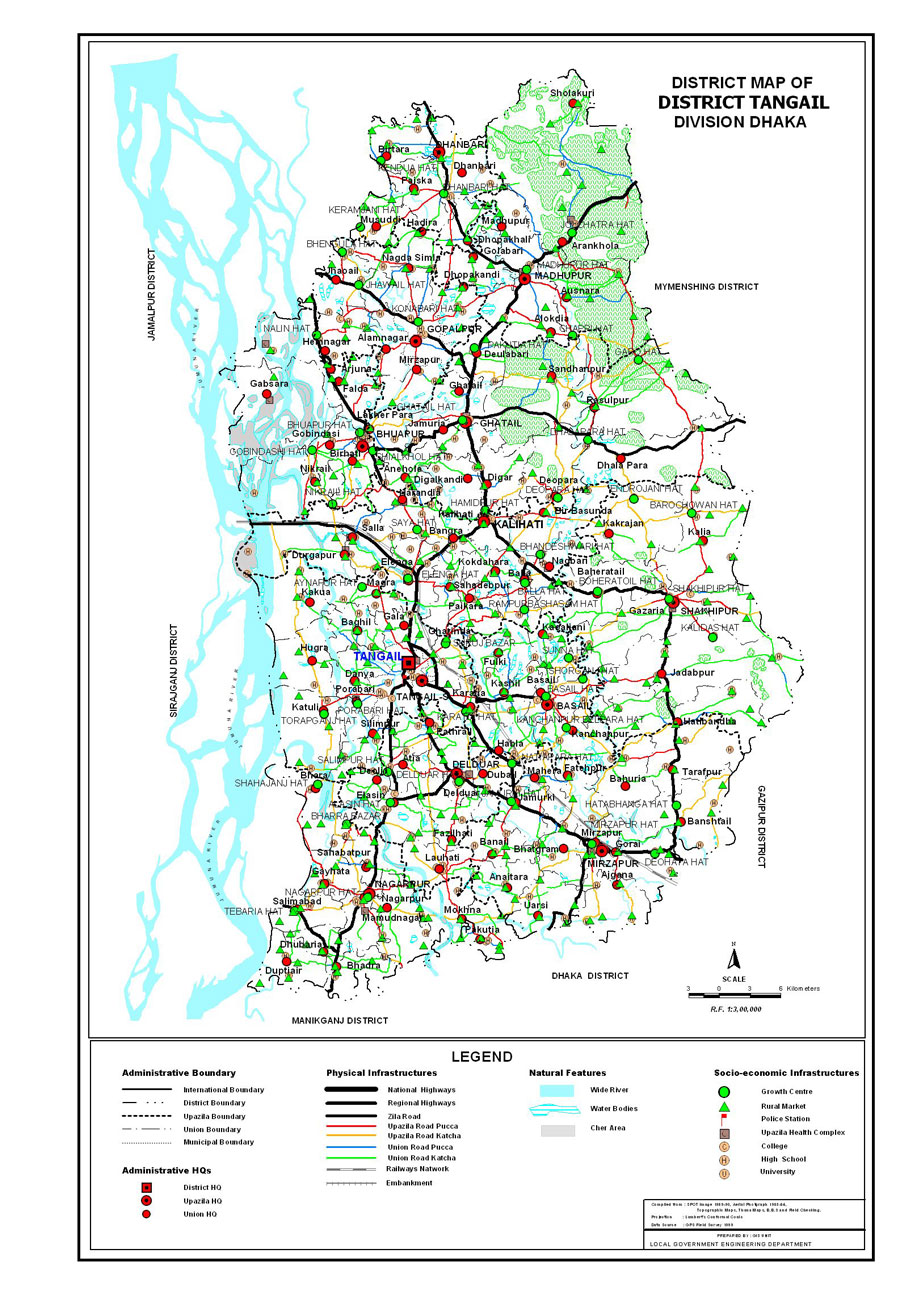
Map of Tangail District. Map Courtesy: LGED Bangladesh
Basic Info
Basic Information |
| Tangail District (Dhaka division) with an area of 3,424.39 sq km, is bounded by jamalpur district on the north, dhaka and manikganj districts on the south, mymensingh and gazipur districts on the east, sirajganj district on the west. Main rivers: jamuna, dhaleshwari, Jhenai, Bangshi, Lohajang, Turag. Madhupur forestry and Sukhipur and Ghatail hillocks are notable. Average annual temperature: maximum 33.3 oC, minimum 12 oC; annual rainfall 1467 mm. |
At a Glance |
|
| Area: | 3,424.39 Km2 |
| Upazila Road: | 909.81 Km |
| Union Road: | 1107.38 Km |
| Village Road: | 2819.76 Km VA |
| 2140.18 Km VB | |
| Population: | 35,08,556 |
| Density: | 975 per Km2 |
| Literacy: | 40.50 % |
| Upazilas: | 12 |
| Union: | 107 |
| Pourashavas: | 8 |
| Primary Schools: | 937 |
| High Schools: | 428 |
| Colleges: | 82 |
- Details
Satkhira District
Maps
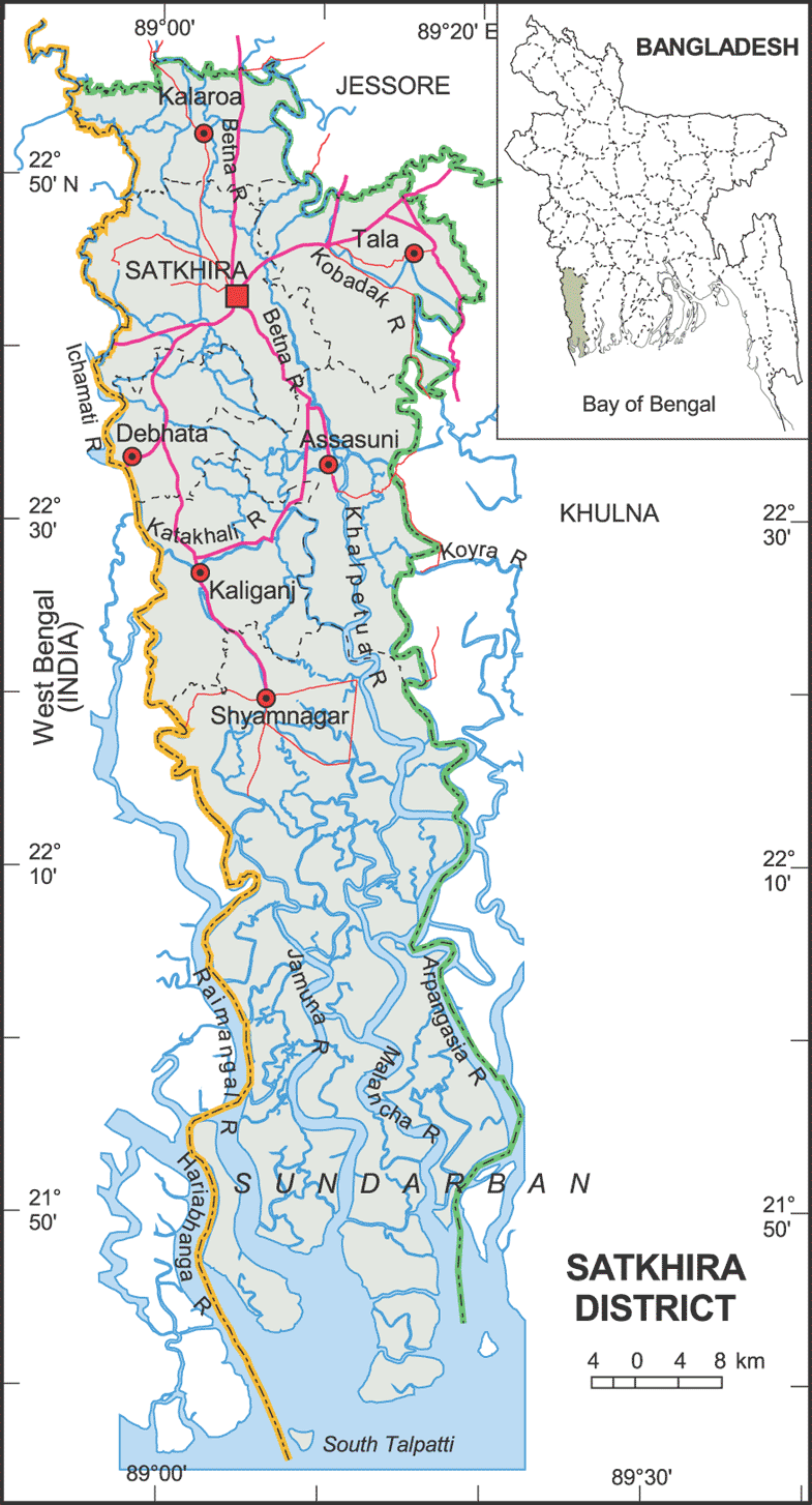
Map of Satkhira District. Map Courtesy: Banglapedia
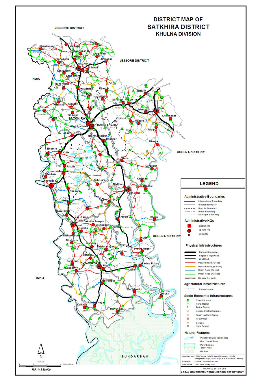
Map of Satkhira District. Map Courtesy: LGED Bangladesh
Basic Info
Basic Information |
| Satkhira District (Khulna division) with an area of 3,858.33 sq km, is a south west bordered district of Bangladesh. It is bounded by jessore district on the north, the bay of bengal on the south, khulna district on the east, Pargana district of west bengal on the west. Annual average temperature is maximum 35.5 oC, minimum 12.5 oC; annual rainfall 1710 mm. The soil of the district is alluvial floodplain. Main rivers are kobadak, Sonai, Kholpatua, Morischap, Raimangal, Hariabhanga, ichamati, Betrabati and kalindi-jamuna. |
At a Glance |
|
| Area: | 3,858.33 Km2 |
| Upazila Road: | 715.10 Km |
| Union Road: | 574.23 Km |
| Village Road: | 2088.12 Km VA |
| 2224.09 Km VB | |
| Population: | 19,49,899 (2001) |
| Density: | 505.57 per Km2 |
| Literacy: | 53.32 % |
| Upazilas: | 7 |
| Union: | 79 |
| Pourashavas: | 2 |
| Primary Schools: | 1205 |
| High Schools: | 296 |
| Colleges: | 63 |
- Details
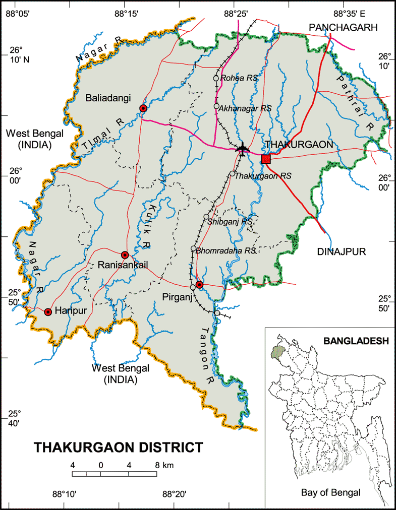
Thakurgaon District
Maps
Map of Thakurgaon District. Map Courtesy: Banglapedia

Map of Thakurgaon District. Map Courtesy: LGED Bangladesh
Basic Info
Basic Information |
| Thakurgaon District (Rangpur division) with an area of 1,809.52 sq km, is bounded by panchagarh district on the north, west bengal of India on the west and south, Panchagarh and dinajpur districts on the east. Annual average temperature: maximum 33.5 oC, minimum 10.5 oC; annual rainfall 2536 mm. Main rivers are tangon, punarbhaba, nagar, Pathari, Talma, Kulic, dhepa. |
At a Glance |
|
| Area: | 1,809.52 Km2 |
| Upazila Road: | 492.54 Km |
| Union Road: | 776.92 Km |
| Village Road: | 1697.06 Km VA |
| 1705.83 Km VB | |
| Population: | 12,95,522 (2001) |
| Density: | 751 per Km2 |
| Literacy: | 65 % |
| Upazilas: | 5 |
| Union: | 51 |
| Pourashavas: | 3 |
| Primary Schools: | 954 |
| High Schools: | 279 |
| Colleges: | 45 |
- Details
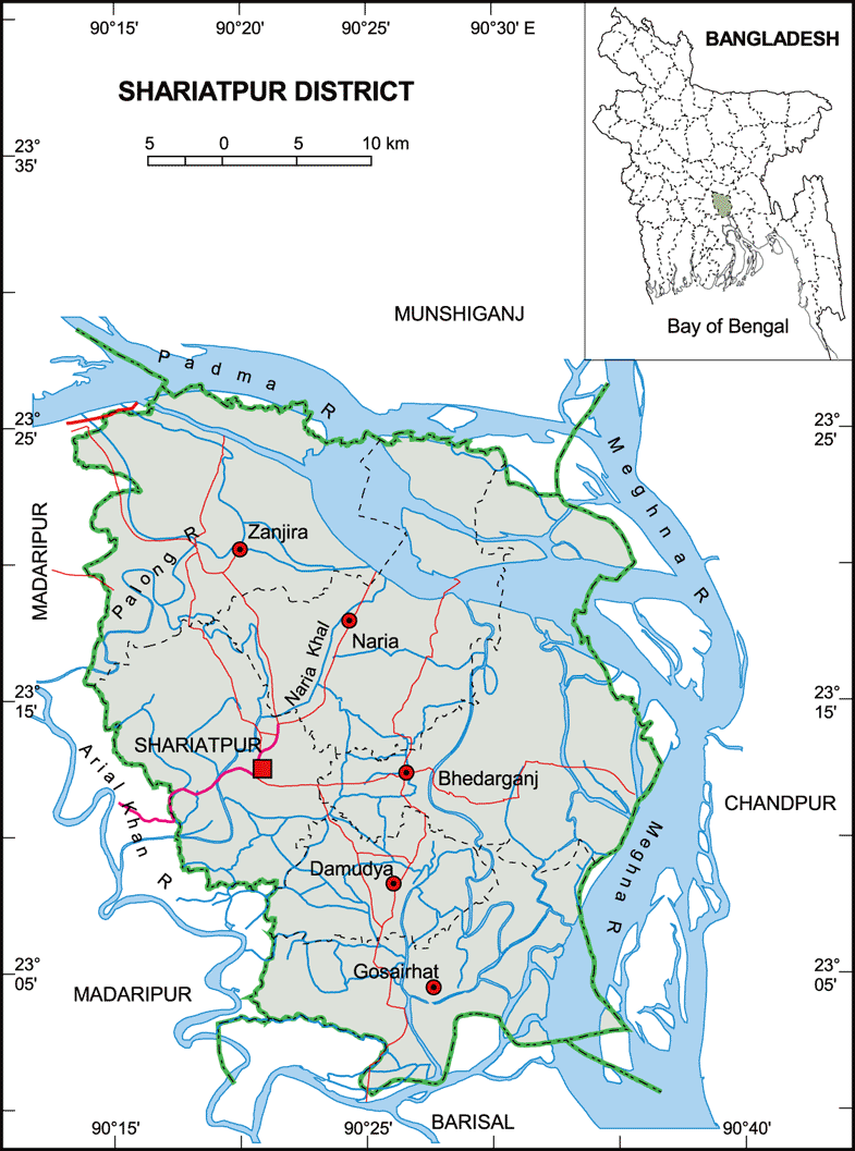
Shariatpur District
Maps
Map of Shariatpur District. Map Courtesy: Banglapedia

Map of Shariatpur District. Map Courtesy: LGED Bangladesh
Basic Info
Basic Information |
| Shariatpur District (Dhaka division) with an area of 1,181.53 sq km, is bounded by munshiganj district on the north, barisal district on the south, chandpur district on the east, madaripur district on the west. Annual average temperature: highest 35.8 oC and lowest 12.6 oC; annual rainfall 2105 mm. Main rivers are Padma, Meghna, Palong and Kirtinasha. |
At a Glance |
|
| Area: | 1,181.53 Km2 |
| Upazila Road: | 295.60 Km |
| Union Road: | 487.75 Km |
| Village Road: | 830.98 Km VA |
| 998.67 Km VB | |
| Population: | 5,38,462 |
| Density: | 488 per Km2 |
| Literacy: | 38.29 % |
| Upazilas: | 6 |
| Union: | 64 |
| Pourashavas: | 5 |
| Primary Schools: | 631 |
| High Schools: | 125 |
| Colleges: | 17 |
- Details